Cyclone Tej Likely to Make Landfall by Weekend Coastal Regions on High Alert
As the Arabian Sea brews yet another potent weather system, Cyclone Tej has steadily intensified into a severe cyclonic storm and is now projected to make landfall along the northwest Indian Ocean coastline by the upcoming weekend. Meteorological agencies from India, Oman, and Yemen have been monitoring the system’s trajectory, and current models suggest that it may strike somewhere between southern Oman and eastern Yemen, bringing with it high speed winds, torrential rain, and severe coastal flooding. While India is expected to remain largely unaffected directly, maritime advisories have already been issued for Gujarat and Maharashtra, warning fishermen and port authorities to exercise extreme caution.
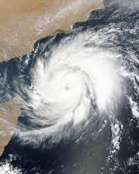
The India Meteorological Department (IMD), in its latest bulletin, reported that Cyclone Tej has been moving in a north northwestward direction, drawing energy from the unusually warm waters of the central Arabian Sea. Sea surface temperatures in the region remain above 30°C ideal conditions for cyclone formation and intensification. As of the latest update, Tej has sustained wind speeds exceeding 100 km/h and is predicted to strengthen further into a very severe cyclonic storm within the next 24 hours. Satellite imagery shows dense convective cloud bands and a well defined eye structure, confirming the system’s increasing strength.
Authorities in Oman have declared a state of preparedness, particularly in the Dhofar and Al Wusta regions, which are considered at highest risk of landfall. The Royal Oman Police, in coordination with civil defense forces, has begun setting up evacuation shelters and pre positioning relief supplies. In Yemen, where civil infrastructure has already been severely strained by ongoing humanitarian crises, the threat of flooding and landslides adds another layer of concern. International agencies like the Red Crescent and UNHCR are on standby, preparing for emergency response if the cyclone makes landfall in already vulnerable provinces like Al Mahrah or Hadramaut.
Though Cyclone Tej is not expected to directly hit India, its wide circulation is likely to affect the Indian coastline indirectly. The IMD has warned of rough sea conditions, high tides, and potential rainfall events along the Konkan coast and Gujarat’s Saurashtra region. Fishing communities have been alerted, and authorities in Diu, Veraval, and Porbandar have been asked to temporarily halt all maritime activities. Indian Navy vessels and Coast Guard ships have been placed on readiness, with helicopters on standby for any sea rescue operations. Western ports, including Kandla and Mundra, are reviewing their emergency protocols as a precaution.
Environmental scientists have noted that the frequency and intensity of Arabian Sea cyclones have seen a marked increase in recent years. Cyclone Tej is yet another indication of the shifting climatic conditions affecting regional weather systems. Historically, most powerful cyclones in the northern Indian Ocean occurred in the Bay of Bengal. However, rising ocean temperatures and altered wind patterns are increasingly giving rise to strong cyclonic activity in the Arabian Sea. Experts point out that just in the past five years, severe cyclones like Nisarga, Tauktae, and Biparjoy have carved paths of destruction across western India and the Middle East.
Public health experts in Oman and Yemen are also concerned about the cyclone’s secondary effects. Heavy rains in arid zones can lead to stagnant water, potentially triggering outbreaks of waterborne diseases such as cholera, especially in Yemen where sanitation systems are already weakened. Flash floods may also disrupt electricity and communications, making timely medical responses more difficult. Past experiences with cyclones in the region such as Cyclone Mekunu in 2018 and Cyclone Shaheen in 2021 demonstrate how even moderate cyclones can lead to widespread disruption in critical infrastructure.
The global meteorological community is closely observing Cyclone Tej’s development. Agencies such as the Joint Typhoon Warning Center (JTWC) and the European Centre for Medium Range Weather Forecasts (ECMWF) have published consensus models projecting landfall between Saturday night and early Sunday. The strength of the storm at landfall will largely depend on if it undergoes rapid intensification in the next 48 hours, a possibility that cannot be ruled out given current sea surface conditions and vertical wind shear data. A rapid intensification phase could escalate Tej into an Extremely Severe Cyclonic Storm with wind speeds exceeding 150 km/h.
Governments across the Arabian Peninsula are treating the storm with heightened vigilance. In Oman, schools in high risk districts have been advised to switch to remote learning modes. Fuel supplies, water tankers, and mobile medical units have been stationed strategically. Civil aviation authorities are monitoring airport operations closely, and shipping lanes are being rerouted. Yemen’s already overstretched emergency management systems have appealed for international support, particularly for early warning dissemination and shelter reinforcement in low lying districts.
In conclusion, Cyclone Tej represents another manifestation of evolving climatic trends that are intensifying the scale and speed of tropical cyclones across the Arabian Sea. While India may be spared a direct hit, the ripple effects in terms of maritime disruption, rainfall anomalies, and storm surges along the western coastline warrant serious attention. For Oman and Yemen, the next 72 hours will be crucial in determining the impact zone and scale of damage. The growing capability of weather prediction systems provides a glimmer of hope, but preparedness on the ground remains the most vital line of defense against nature’s fury.